I can see my house from here - part 1
Some other Wellington bloggers have mentioned the view of Wellington from space that's available on Google Maps and Google Earth, so I thought I'd have a look at the various views of Wellington that are available on the web. Google Maps seems to use the same satellite imagery as Google Earth, but the latter adds all that juicy 3D functionality, so I'll start with that.
Google Earth has a competitor: NASA's World Wind. There's some debate as to which is best in terms of usability, functionality and performance, with no clear winner as far as I can tell, so I'll concentrate on the quality of imagery available for Wellington.
 Oh dear. World Wind has a real problem with its detailed LandSat data for us: there's a double image, and neither matches the placenames! This only affects the Wellington region, and for the rest of the country, World Wind's imagery looks as good as if not better than Google's. Google has some odd placenames (Titahi Bay drop's its 'h', and where on earth is "Yoxon"?!?) and some might quibble that the false colour looks a little too false, but otherwise Google Earth has to be the winner at this scale.
 Zooming into the CBD, we can see that neither is particularly good compared to the resolution available elsewhere in the world (you can't see trees and cars like you can in Sydney). World Wind appears to have marginally more detail, but it might just be that Google have tried to over-sharpen their images to give a crisper look, resulting in a blobby image with blown-out highlights. World Wind's darker look is probably due to the double-image problem, with a translucent texture getting overlaid on the sea. Google offers a hotlink for Wellington (the red dot), but all it does is trigger a Google search on the word "Wellington", giving all sorts of false hits for things other than the city of Wellington, New Zealand.
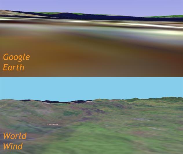 Both applications offer 3D capability, allowing you to fly over the terrain. Here are two screenshots looking from approximately Te Aro towards the Hutt Valley.
No, that's not a Tsunami washing over Ngauranga and up to Newlands (however much that might improve the architectural standards there...). Google's elevation model is fairly chunky, resulting in some of the water being mapped onto the pyramidal hills. World Wind is knobbled from the start, given its texture problems for Wellington, but the hills are definitely smoother and of higher resolution. The rest of the country offers some wonderful opportunities for virtual fly-bys: it's just a pity that we don't get the same opportunity for Welly.
 For really high resolution images, you have to go to the LINZ website and download some orthophotos. Orthophotos are defined as aerial photos with any distortion removed. If you look at LINZ's Wellington page, you'll see that these photos are black and white rather than colour, but that the images are available in a range of resolutions, right up to 46MB uncompressed tiffs with pixels representing 2.5m x 2.5m squares on the ground. The image at the right is a detail from the highest resolution pic: if you click on it you'll see individual trees and waves on the harbour. The images are a bit old (2000-01, so you can see Te Papa but not Courtenay Central), but endlessly fascinating nonetheless.
Unfortunately, it's LINZ's requirement to return revenue that (as far as I know) make these images unavailable for applications like Google Earth and World Wind. Most developed countries (and the USA) have plenty of high-res imagery available for free on the web, but not us. Since World Wind is an open source project, it might be possible to add these orthophotos to their application, but they're not geo-references, so a bit of manual work would be required.
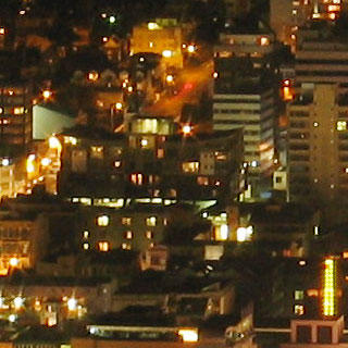 Finally, for a slightly less aerial view of Wellington, have a look at this magnificent nighttime panorama of Wellington taken from Mt Victoria. The page shows a low-res version with information, and links to the full version in all its 13939 x 1788 pixel glory. The little thumbnail I have here just shows one insignificant part of Te Aro: the full panorama stretches from Newtown to Kaiwharawhara.
In the next instalments: more photography, maps, historical guides, satellite pictures and webcams.
posted by Tom @ 1:14 pm
![]()
![]()


2 Comments:
Thanks for a fascinating post. Just read this article in Nature about a guy discovering a Roman archaeological site via Google Earth. Probably not much chance of that happening here until Google ups the res of its pix of New Zealand, and in any case, hardly like to find the remains of structures a couple of thousand years old...
Andrew
Thanks for the link, Andrew. World Wind are also in on the act: it's apparently been used to locate Homer's Ithaca.
And you're right about the unlikeliness of it happening here until the res gets better. I blame LINZ, or rather the requirement for LINZ to be a commercial entity rather than releasing the imagery under some sort of creative commons license. And yes, there are unlikely to be any 2000-year-old villas, but maybe the odd pa site from a few hundred years ago.
Post a Comment
<< Home