Back on track: the numbers game
After my last post mentioning that the Dominion Post article had a serious typo (stating that only 56 rather than 456 people supported light rail), I didn't bother writing in to correct them, assuming that such a glaring error must have been picked up and corrected since then. I still haven't seen any such correction, and from a letter in today's paper it's clear that even rail supporters are still being misled by the mistake. So I fired off a quick letter to (hopefully) correct the misconception that virtually no-one supports light rail:
Kevin Anderson is right to point out that rail is cleaner, more popular and more space-efficient that buses or busways. He is also right to be sceptical about support for the busway, given that 87% of the support came on pro-forma submission forms provided and promoted by a vested commercial interest.
He is wrong, however, to say that rail and light rail attracted a combined total of 645 supporters. The figure is actually 1045, since light rail was supported by 456 people rather than the mere 56 that your article erroneously reported. It's not really possible to add the options together, since submitters could choose multiple options, but nevertheless Kevin Anderson can be assured that support for rail is much greater than your article suggested.
I've also previously questioned the definition of "North Wellington" that includes suburbs far from the Johnsonville line, when all of the proposed options centre on the future of the line. Criticising the Johnsonville line for not serving Woodridge makes as much sense as me blaming the Eastbourne ferry for not helping me get from Te Aro to Lambton Quay. Thankfully, the summary of submissions (350kB PDF) breaks them down by suburb (page 15) and into three geographic clusters. The cluster that is actually served by the Johnsonville line comes out strongly in support of rail, even if you include the Bus & Coach Association forms:
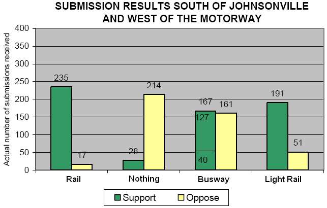
This clearly shows the popularity of rail compared to a busway along the same route.
It's also worth noting that the busway option would be incompatible with some of the council's stated policies. The report on council responses to peak oil (115kB PDF) recommends that the council should "agree to take into account the peak oil issue and rising fuel prices when making future transport investment decisions, by promoting and designing a transport system that encourages more efficient use of and reduced reliance on oil-based products." Specifically, "because very little electricity is generated from oil in New Zealand, the Council's support for electricity-based transport options is an important way to reduce oil dependency." In this context, it hardly makes sense to replace an electric rail line with diesel buses.
Secondly, it's notable that among the reasons for supporting the busway cited by submitters (page 29 of the summary), "potential for growth in northern suburbs" was listed as an advantage. Given that the council's Urban Development Strategy is committed to focussing most population growth along a compact "growth spine" (Johnsonville - CBD - Airport), encouraging more sprawl in the suburbs north of there seems like a distinct disadvantage.
To sum up: people who use the train don't want it converted to a busway; buses are incompatible with the council's peak oil advice; and the busway would encourage growth where the council doesn't want it.
posted by Tom @ 5:07 pm
![]()
![]()


31 Comments:
Keep us posted on whether the Dom Post acknowledges their 'mistake', and how much of a billing their correction (if any) gets.
Tom, you continue to claim "that rail is cleaner, more popular and more space-efficient that buses or busways." This has been refuted in a When Service Conditions are Equal on the pro-busway blog Better Bus
The North Wellington Public Transport Study (NWPTS) is not about preserving or replacing the Johnsonville Rail Line. It is about determining the best Public Transport Service for North Wellington.
What the Stage 2 study Report has found is:
* Of the 3,000 daily users of Public Transport, most (1,800) choose to take the bus (no, rail is not so popular here in North Wellington)
* Three of the four scenarios predict that bus PT users face an increasingly worse (travel times becoming 20% longer) public transport service due to congestion.
* Only the Busway scenario provides an improved PT service the whole of North Wellington.
So it really no surprise that residents and ratepayers from areas served by buses submitted their wish for access to a good quality PT service just like the rail users. Bus users face trip time increases of 10 mins over the next ten years because they must travel through choked Ngarunga and Ngaio Gorge traffic. This is over an hour and a half per week out of every person's life . . . time that would be better spend with family, friends or work.
This is really not about rail or bus, it is about public transport for real people across North Wellington. It is clear that, overall, the passenger rail and busway based rail-replacement service are very similar in their service. The key difference (as oulined by Better Bus) is the service provided to areas away from the rail.
The study has accepted all submissions and that the clear majority of the submissions is in favour of the option that provides the best public transport service to all (in fact the submissions favouring the two modes roughly match the current level of users of those modes including the respective levels from each area).
My question to the pro-rail supporters is this:
do you think it is fair that the good quality bus service currently available to the people of Newlands and Churton Park should be sacrificed so that the residents of Khandallah and Ngaio can take continue to take the train ?
I don't profess to have studied any of the details of these proposals rigorously - but it seems to me that all your arguments Tony could be met through two simple changes:
- integrated ticketing between buses and trains, and
- turning Johnsonville into a true interchange, with bus service feeders from Newlands, Churton Park, etc.
You get all the advantages of the busway, with no buses having to traverse the heavily trafficed roads, without the expense of ripping up the rails and adding to carbon emmissions. Of course, it does mean that the bus company has to give up the majority of their fare, and that to me seems to be the sticking point, from their webpage.
The Regional Council has had vague plans for years of building a station at Glenside, just outside the tunnel. And yet I can find no mention of this in the NWPT study, not even in the background stuff.
Could this be because the proposed station site is just outside the study area? If so, this is a flaw of the very narrowly defined study area. This study even mentions an underground rail extension (and why its not affordable for Wellington).
I think that a Glenside rail station with feeder buses from Churton Park could provide a good peak service, particularly to those who work within easy walking distance of Wellington station. It could also be a good interchange for services to/from the new Lincolnshire Farm development and, if that Hutt link road is ever built, interchange for direct Hutt services that could run from, say, Tawa.
Train from Glenside to Wellington would take about 10min. Assume interchange takes about 4min and that travel along Middleton Rd to Halswater is allowed 2min. Based on current timings and timepoints for the Churton Park loop, but assuming bidirectional running, times are:
Wellington from
Halswater Drive 16min (bus 35min, or 21min via Middleton Rd #59)
Amesbury Drive 19min (bus 32min)
Cambrian Street 27min (bus 26min)
In the other direction train/bus times could probably be reduced by a couple of minutes by having the bus waiting when the train arrives and leaving as soon as passengers finish leaving the station (as is done at Porirua during the evening peak).
Travel times up the line would be increased by a couple of minutes.
Overall comment to both Colin and Anonymous . . . people do not like to interchange (actually if you were real PT users you would know we hate it!). Very few rail users take the bus to the station in Wellington today.
On the issue of Glenside Station,
the Western Corridor Study considered rail stations at both Glenside and Newlands. The key WCS report is
Rail Issues and Options (TR8) - April 2005.
WRT Glenside, the report outlines the option, impact of the option and the conclusion respectively
7.3.4 RS4 - New rail station at Glenside
This proposed station site is adjacent to the northern portal of No2 Tunnel, south of Takapu Station. There appears to be little hinterland from which this station can draw patronage. It would take significant development to occur north of Glenside in an area that is not necessarily suitable for urban development due to terrain and flora reservations.
6.3 Improving accessibility
. . .
Additional Stations - Additional stations have been proposed at Cruickshank Road, Raumati, Lindale, Timberlea, Glenside, Newlands, MacKays, and Aotea. It should be noted that the greater the number of stops that are incorporated into train timetables then the longer the journey time which works against the objectives discussed in Section 6.1 above.
7.7 Summary of Elements
The following table categorises the elements into those that could value to the development of rail services in the Western Corridor (dependent on patronage demand assessment), and those that have been identified as adding little value or providing poor value for money.
. . .
RS4 New Rail Station at Glenside X
RS5 New rail Station at Newlands X
(X = Not important to the Corridor)
The bottom line is, you cannot have stations south of Tawa if you want increase rail capacity north of Tawa (the WCS even recommends closing two current stations to enable increased rail capacity). Trains cannot pass trains.
Finally, the people of North Wellington have already shown how much they will use a direct to CBD PT Service. As recorded in the Scenarios report part 2 - Context(on right of page):
3.3 Wellington CBD
All rail journeys currently finish at the Wellington Railway Station which is located at the northern end of the CBD, adjacent to the Lambton Bus Interchange. Bus routes enter the CBD from various directions and are directed through a single CBD bus corridor between the Lambton Bus Interchange and Courtenay Place.
The benefits of extending public transport services from the railway station through the CBD are highlighted by the large patronage increases achieved when Newlands bus services were reorganised in 2000 and extended from Lambton Bus Interchange through to Courtney Place (that is, a seamless service was implemented through the CBD). This resulted in a 40% increase in patronage as frequency increased and a seamless service provided where passengers were able to travel through the CBD without having to interchange.
Bold added for emphasis.
Why deny this level of PT service to the whole area in the future ?
Tony, addressing your interchange comment - is this anecdotal, or do you have evidence? I would question that PT users inherently do not like to... I am not a North Wellingtonian, and am lucky enough in Hataitai to be able to walk/cycle/bus with equal ease - but until five years ago I lived in the Hutt, and either walked, cycled or drove to the bus stop (3km), bussed to Petone Rly stn (10km), then caught the train, every day. I'd say that's real PT usage!
Anyway, back to your statement - as well as my own experience in the Hutt, nearly all medium-large cities I've been in overseas have interchanges of this type that are highly patronised - and the key is the integrated ticketing (and either services timed to meet each other, or frequent enough that it doesn't matter). The change in mode is not such a big deal if you don't have to buy a new ticket each time. Currently Wgtn only has the Starpss ($10 for one day) or Platinum pass ($165 for one month), which are both extortionate. Using the new zone system, a trip from Churton Park to Wgtn should be 3 zones, no matter how many modal shifts you go through.
I'm happy to be proved wrong by a study, but I don't think you should be too quick to come to conclusions about what PT users hate!
In support of my assertion that bus to train interchange will only be used by a small percentage of Wellington PT users, I cite the GWRC Passenger Survey 2002 Table 10
Q4b How did you get to the bus Stop/station ? Overall & [Train user]
Walk 10 mins or less 71% [52%]
Walk more than 10 mins 11% [22%]
(Another) bus 6% [8%]
Drove Car and Parked 4% [9%]
Dropped off by Car 3% [7%]
{Another) train 3% [1%]
Cycle 0% [0%]
Most people walk and so PT mainly serves those within walking distance.
Within Wellington City, there are only two places you can (reasonably) get a bus to the train station: Johnsonville and Wellington Stations. And since you'd have to pay another fare to get a train from Johnsonville, nobody does it. It's not really a fair comparison to integrated ticketing. Only in the other constituents of GWRC can you reasonably get a bus to the train station.
A lot of people do get a bus to Wellington Station on their way home, which is generally excluded by those questions (it's always "when you went to work" or similar). I don't know if it is in this case, but I suspect it is a contributing factor regardless, because people wouldn't think of that when filling it out.
Colin,
Unfortunately, interchanging at Johnsonville does not give all the advantages of the busway. In addition to the obvious (the actual time delay in interchanging, and the lack of seamless service through to the CBD) there are two less obvious points:
- travel time. Even the upgraded trains will take about 21 minutes to get from JVille to Wellington. That's over 50% longer than an off-peak bus on road, and up to 40% longer than an on-peak busway bus (exact busway travel times are yet to be finalised, the 40% difference assumes the fastest potential travel time mentioned in the Council's report)
- frequency. Bus users are accustomed to 5-minute on-peak frequency already. The busway will offer the same 5-min frequency to rail users.
The Glenside option is interesting, but does have difficulties with the delay effect on passengers from futher north and, I suspect, with the psycological effect of having to travel away from one's destination (for a significant distance in some cases) to catch the train.
Yes, I will continue to state "that rail is cleaner, more popular and more space-efficient that buses or busways," and John's post in no way refutes that. He says that "The fair comparison would be between trains on tracks and buses on busways ... I suspect preferences might be split down the middle, amongst existing rail users." The graph that I displayed shows that among the suburbs that are served by the Jville line, both rail and light rail were preferred over the busway. That gives me local evidence to back up my claim that rail is more popular than buses.
Neither your comments nor John's post address the cleaner and more space-efficient nature of electric rail.
If the definition of "North Wellington" is allowed to take in Newlands and Churton Park, then why doesn't it take in Tawa as well? After all, it's part of Wellington. Perhaps because it's served by a railway line?
My argument is not about trying to provide the same level of PT service to all forms of urban development: it's about the integrated planning of transport and urban form. The sort of low-density sprawling suburbs that characterise your definition of "North Wellington" can never support the efficient mass transit lines that moderate density linear neightbourhoods can.
I made the Glenside comments and yes I am a real PT user. I would happily interchange to save a significant amount of time, particularly with a decent, integrated ticket system. I agree that the ideal is fast, direct, seasmless service (wouldn't we all?) but don't think that that is achieveable in all cases. This is idea is not meant to a replacement for direct bus services (be they on-road or busway or whatever) but a supplement to them. It would use spare bus capacity in the counter peak direction (buses would return as direct through services).
Concerning increased travel time on the Paraparaumu line. Proposed increase in service frequency on the Paraparaumu and Hutt lines will likely require something to be done to removed conflicts and the accompanying delays at Kaiwharawhara already experienced in the peak. Time saved by this and catching up on deferred track maintaince might allow for the introduction of an additional station with no or little effect on actual running time.
I think the example of the increase in bus patronage with the extension of the northern suburbs routes was not necessarily all due to the seamless service, but also influenced by time savings and financial savings (not having to buy two completely different tickets). Also, there was no alternative faster option.
John, I am curious as to the motivations behind you pro-bus stance. I ask, not as a slant against any bias you may hold - everyone no matter how objective they attempt to be has their biases. However in all the continued debate around the Northern transport study your name keep surfacing [and a good thing too, we are well short of people who care enough to speak out!] .
Do you have any connection to the bus and coach industry? I know you attempt to introduce facts in your arguments however you seem very reluctant to look at or address both points of view -or indeed a wider context.
Any future decisions will inherently be long term -Wellington is not Singapore and we cannot create tabula rassa conditions every decade as such our time-frame needs to be the next 50-100 years . It seems ridiculous to choose a mode that relies on an increasingly finite, expensive and unstable commodity. Furthermore no one, it seems is prepared to address the popularity or mode-shift factors in this debate. Understanding why people choose rail over bus is a critically important component, knowing more about sense-of-place issues, service provision and perception is key.
However even more critical is having a well communicated long term plan/vision for transport in the region. - the choice made on the northern transport corridor would make a lot more sense when understood from a wider context. If a commitment was made to establish a rail link to the airport, Grenada north etc as part of a long term plan then decisions about more localised issues would be increasingly obvious. From my understanding this 'wider vision' is on the cards but is either not finished or not communicated effectively enough to become part of this debate?
Thanks everyone Tom and everyone for all this information. I find this blog and comments very thought provoking and a great forum for debate.
I have a couple of points to add myself.
First, I understand Tawa is not included in the study because it is serviced by a different bus service that doesn't really interact with the rest of the northern suburbs. Is this really the case?
Secondly, the question of a Glenside station, as rightly pointed out, was dealt with by the Western Corridor Plan. This station would not be on the Johnsonville line and I believe has been excluded for the same reason Tawa has.
Thirdly, which has the better environmental outcomes for the northern suburbs? Buses or trains? Trains use electricity, but a proportion of NZ's electricity supply is generated thermally. Buses use diesel, but they are becoming more efficient as technology advances and could also use alternatives such as hybrid.
There is also the issue of embedded energy - a train requires a lot more resources to construct as reflected in its cost ($3m plus for a new train versus $0.3m for a new low emission diesel bus) but a train does last longer than a bus.
What I would like to know is the full lifecycle energy use/costs/emissions of train versus bus over a 25 year period. This would include accounting for embedded energy in constructing and transporting the units themselves, generation/refining and transmission/transportation of fuel, efficiency of use of this fuel. This could then be related to energy use per passenger. It would be really interesting to compare this to car emissions. Who wants to do a research project?
I had some other points but I think that is enough to think about.
Leaving aside (for the moment) the bus vs train argument, the Economist has a reasonable lay-persons article about public transport and its take-up in the States.
Tawa is served by the 59 (Wellington-)Johnsonville-Porirua bus. It runs to/from town twice in the morning and evening, but otherwise just between Johnsonville and Porirua via Tawa and Kenepuru. It is a Mana-branded, as opposed to Newlands, bus, but they're not really any different.
It does interact in the sense of scheduled transfers at Johnsonville to and from the various other buses and the couple of city services each day, but no more than that. Actually, given that, you'd think they really should be included, since transfers at Johnsonville should really be a key part of that plan.
Seems amazing to me that people are even considering ripping out an existing rail line given the global trends and regrets from the past. If a busway is necessary add bus lanes to the motorway. There are plans to widen the section from Ngauranga to Aotea to 8 lanes.
Part of the problem is Wellington isn't ambitious enough with its transport wishes. That's why we ended up with a bypass instead of a covered tunnel. That's why rail still stops at the edge of the city.
Instead of developing a long term vision about what we really want, and then progressing towards that with each new development, we end up with a hodgepodge of infrastructure that becomes more expensive and hard to upgrade. The bypass was one example, converting the Johnsonville line would just become another example.
Tom,
I do not know why you continue to labour the point in your posts "that rail is cleaner, more popular and more space-efficient that buses or busways".
Even if rail was superior (and John & I do not agree), this only applies to the minority living close to the rail line. An ever increasing majority live away from the Rail Line and will continue to rely on buses for their public transport.
And let us not forget that the main point of public transport is to be an alternative to cars. Every bus load (and the buses are full) means 40 - 50 cars off the road. Improving the rail service patronage by 20% means 260 more people from cars, but the bus service losing 20% means 360 more people going back to cars. The difference in bus or rail fuel usage or envirnmental impact is insignificant compared to the impact of changes in car usage.
In the last 20 years bus services, esp. Newlands Coach Services, has grown (while the passenger rail usage has fallen) with a major reason being the frequent, direct service now available (as I outlined at the end of my earlier post).
The bus service is, outside peak time, is faster (at 16 mins) than the rail service (at 21 mins). The only problem is peak time congestion caused by having to share the road with peak car traffic. Johnsonville-Wellington peak bus travel times are already double off-peak and the North Wellington Study predicts they will increase another 20% !
The only scenario that preserves the current successful bus service is to have a busway down the Johnsonville Rail Corridor. There is no money to fund separate bus lanes on the Wellington Urban Motorway. Having buses travel to Johnsonville and interchange with the rail will be a worse service to users than they have now. And given that 40% of users have started using the bus service since it travelled through the CBD, it is highly likely that this 40% (perhaps 600 people) would go back to cars if forced to interchange (again) at the railway station.
So do the rail scenario supporters have anything better for the residents of Newlands and Churton Park than a third-class public transport service as the price to get a first class rail service to Khandallah and Ngiao ?
The bus service is not every sixteen minutes outside peak time, it is every thirty, ramping up through fifteen to ten and back either side of the peak.
One train can carry far more people than one bus; in fact service frequency is not really the appropriate metric here, since trains can have extra carriages for busier periods while retaining the same frequency.
Unidirectionality is probably the stupidest aspect of this plan, since a lot of the current train usage is against the supposed "peak" direction. For example, Raroa Station services Raroa Intermediate and Onslow College - both of which, for obvious reasons, against the peak flow. This is roughly six or seven hundred people in total, or over ten busloads leaving simultaneously.
Screwing over everybody south of Johnsonville is not an effective strategy. Like you say, Churton Park and Newlands already have effective bus services.
"The only scenario that preserves the current successful bus service is to have a busway down the Johnsonville Rail Corridor."
I don't see any way in which that statement is not false. It should also have appended "... and destroying the current successful train service".
Simon,
I've answered your questions about me on my own blog.
As for all the other great stuff in this comment thread, perhaps I'll have time to respond another day...
Anonymous comments "The bus service is not every sixteen minutes outside peak time, it is every thirty, . . .". An accurate description of the bus frequency but My comment was about Johnsonville-Wellington travel time !. Except for peak hours, the direct bus service is already faster than the train. Even at peak hours the (Johnsonville-Wellington) travel time is usually 25 mins (a bit less less from Newlands-Wellington).
The Study predicts increased congestion will add another 20% onto the peak bus travel times.
Anonymous and others have a proposed alternative of having buses travel to Johnsonville and interchange to rail (and then back to buses for many commuters). Apart from having to change modes, this is also likely to mean a much longer travel time for users from areas served by buses.
With the Busway Scenario, peak hour/peak direction bus travel times are significantly improved. For example Johnsonville-Wellington travel time improves from about 25 mins to between 17 - 15 minutes (NWPTS Tech Appendicies Section E.3.9 (Acrobat 2.5Mb), (Newlands users have a smaller gain as they have to travel to Johnsonville to use the Busway). Just as important, travel schedule reliability is also improved as buses will avoid the period crashes and other unforseen hold-ups that afflict the Ngaurunga Gorge merge.
As for the numbers travelling counter-peak, I have the following to say:
* I have asked both Raroa Intermediate and Onslow Colleges and the student volumes are nothing as large as you state. Can you confirm your source for the claim of "This is roughly six or seven hundred people in total, or over ten busloads leaving simultaneously." was not your keyboard ?
* There are already a number of school buses travelling from areas of Khandallah, Ngiao and beyond to the school.
* There are also a number of school buses bringing student from Johnsonville and Churton Park that may not be needed because student can use public transport to get to these schools
* Onslow College is already served by 9-10 school buses, nearly as many students travel there by bus as train now !.
I do not agree that changing the rail service to a busway is "Screwing over everybody south of Johnsonville". The rail replacement service is as fast and reliable (as well as being more frequent and seamless to the CBD) as the current rail service.
I do agree with your statement "Churton Park and Newlands already have effective bus services.". My question to rail supporters, how can the current effective bus from Newlands/Woodridge/Grenada Village/Churton Park/Jville to Wellington be maintained in the Rail Scenarios ?
On the topic of reliability, the Gorge/Hutt Rd route is very suceptible to accidents and other delays. One morning last week, it took me an hour and 10 minutes to get to work. (Including the extra 20 minutes waiting for the traffic-delayed bus to even arrive to pick us up.)
The busway is not screwing everyone to the South of J'Ville; but I suggest that the rail option is screwing everyone to the North.
My source is myself; I was there not that long ago, and at Raroa five years before that. There are a few hundred people at Onslow using the train from Raroa Station, and (when I was there) roughly 200 of the 500 students at Raroa. I don't know what the total student number at Raroa is now, so adjust accordingly.
Yes, Onslow is served by around ten buses already, mostly shared with other schools. Raroa has two of its own. Adding an additional multitude of buses - dedicated buses, too, so it's not even as efficient - isn't made any better by that. I don't think "it would only require doubling the buses!" is much of an argument. There's also a lack of the physical room to do that, it's just implausible. Both these cases would suffer hugely under this plan.
The bus services can survive by, and here's a shocker - doing nothing. They're totally unaffected.
Has there ever been any investigation into extending the Johnsonville line as light rail through Newlands so that it can serve these new low-density, poorly connected, suburbs that are springing up north of Wellington, and serve the rediculous planning ideas such as the Lincolnshire Farm Business Park? If not why hasn't this been done, and if so why hasn't the appropriate reserves been created to allow the later construction, or such requirements been placed on gaining approval for the developments?
I don't know where to start on Tony's apparent view that people in Khandalla and Ngaio should have to give up their rail service for the other suburbs.
The Khandalla/Ngaio area is in reality an early example of TOD, these suburbs developed DUE to the rail line, not fat pockets and 4x4s.
Imagine if everyone moved 50kms out of the city, say to some rural place like Kapiti, and low-and-behold the roads couldn't cope with the rediculous amount of commuting, and they all then demanded the rest of the region and all those sensible people that chose to remain close to where they worked, pay 1 billion dollars for a motorway just for them, so they can get to work 5 minutes earlier. That would be called rediculous planning. Oh wait. It happened. The low-density suburbs springing up in North Wellington with no decent transit planing or requirements are just a smaller case of this. If they want to use buses, and want a busway, then developers should pay for a busway as part of the developments.
I don't think it's really possible to extend the Johnsonville line into Newlands or Churton Park; they're simply too spread out already in design that station density would have to be far too high versus passenger density. Getting out of Johnsonville station would be a difficulty too, it's fairly blocked in on that end. Both of those have been mooted from time to time but it's never gone anywhere because of that.
For light rail, an extension into Newlands would certainly be possible. The only doubt I'd have is whether it would be plausible for it to get up the hill, somebody more well-versed in the topic could answer that. Alternatively of course, it could go through Paparangi and in that way, which wouldn't be too bad (perhaps better). Even extending to a couple of stops in Churton Park or up into Johnsonville West wouldn't be unreasonable.
In terms of extending light rail from Johnsonville, I have seen one proposal utilising the existing road bridge over the motorway - can't find the document online though. Staying on the west side of the motorway, I can't comment on density, as I've said before I don't know the area well, but until the two Tawa tunnels were built, the Johnsonville line was the NIMT - it DID extend past jville. Not sure what's been built since, but again I'm sure with light rail on existing roads you could do it.
With the number of comments both in this survey, and phase 1 of the Ngauranga to Airport saying they need to be considered in tandem, I don't think anything will happen until that is done. This document on transits website says Phase 2 is meant to run Aug 24th - Sep 20th... Tom, (or anyone else), have you heard anything? This time frame is almost over now.
Colin: thanks for pointing that out. I had an email yesterday from the Opus project team, announcing that those documents were now officially up on the site. The timeframe for phase 2 consultation mentioned in the doc is not mentioned in the email, and instead there's this:
"The project team is now developing transportation options and initiatives to address the issues identified in the Problem Framing Report, including the
issues raised during Stage 1 consultation. Further consultation is programmed for early next year and the project team will be interested in your feedback on these options." [my emphasis]
Early next year! That's a delay of at least 4 months, and pretty much without public warning (since the submitters have only now heard from the authorities). Perhaps some of the "key stakeholders" are already involved in one-to-one consultation, and it's only us "general public" that gets to wait. If anyone reading this is among the key stakeholders, can you confirm whether or not Transit etc are talking to you?
It's worth noting when the transport options are developed, that these are the concluding two paragraphs of the report on Phase 1 consultation:
"There is good support for public transport, especially light rail, with a route through the city to the airport a popular topic. Improved access to the airport, walking and cycling and protection of heritage and urban form were also issues frequently commented on
It can be concluded that those that gave feedback seem to think that problems on the the corridor are not caused by roads, but the number of cars on them which can be decreased by public transport."
I don't see how the Johnsonville line could be extended northwards now (with trains), because there's just no way out. Even if the mall were willing to give up some of its area for the direct exit, getting over the roads around that would be nigh-on impossible - they're just not pointed the right way. I guess it's conceivable if a (very long) tunnel were built, but that's just not going to happen.
Light rail that could run on the existing roads is perfectly plausible though. The problem I saw wasn't getting over the motorway - that's the same way I saw it happening - but that when it's over, it has to go up a steep hill, and I wasn't sure if light rail could manage that (I'm thinking of the Raurimu Spiral). The alternative, taking a left turn around through Paparangi, has a much lower gradient.
I think an extension into Newlands is completely plausible if the hill is negociable. I'd have to go for a wander around the Paparangi way to see how that would work out, my memory is a little hazy on that point. Getting into Churton Park and Johnsonville West would be desirable too, but there mayn't be the passenger density for it.
I'm glad to hear that light rail is being considered seriously for the airport link, which could bode well for it on the Johnsonville line.
For those who are skeptical it can be a success, I've been to London not too long ago and stayed in Croydon, which is the hub of the absolutely fantastic Tramlink service. It is everything you could possibly wish for - efficient, clean, regular, and comprehensive.
Interesting that a number of the comments that oppose the rail/LRT options talk as if they assume that if a rail option is chosen they will be forced to transfer to rail at Johnsonville.
In reality no direct bus services would be converted to feeder buses under any of the options proposed and in fact all options include improvements to bus services, busway or no busway.
Well actually, it has been the rail supporters like Colin and Anonymous that proposed interchanging with rail as a valid alternative for bus users to the increasing slower and more unreliable direct bus services via Ngaruanga Gorge.
Both John Rusk and myself have pointed out Interchange only works for a minority of users, and is likely to be at least as slow for bus users as the increasingly congested Ngaruanga Gorge route.
The key question for the Rail Scenario supporters remains unanswered:"how can the current growing, effective bus service from Newlands/Woodridge/Grenada Village/Churton Park/Jville to Wellington be maintained in the Rail Scenarios ?"
Of course, no rail supporter (including Tom Beard) has been able to refute the obvious, that an increasingly slower and more unreliable direct bus service to Newlands, Broadmeadows and Churton Park is part of the price "they" are prepared for bus users to pay, to keep the rail service.
Bus services from Newlands/Woodridge/Grenada Village/Churton Park/Jville to Wellington will only be affected if urban sprawl continues in those and even more distant suburbs. With appropriate strategies to stop sprawl, combined with travel demand management and high-occupancy lanes on the motorway, there's no reason why increased congestion should be inevitable.
But it's obvious that you see the busway's promotion of urban sprawl as its main advantage, rather than a disadvantage.
Tom, you say "Bus services from Newlands/Woodridge/Grenada Village/Churton Park/Jville to Wellington will only be affected if urban sprawl continues in those and even more distant suburbs."
You well may be correct, but, as an affected resident, I can only say "If only balony". The population growth is both predicted and included in the approved city growth plans by the respective Councils.
More specifically, Scenarios report part 2 - Context (1.4 MB PDF) Section 2.3 includes the following statement:
The population of the northern suburbs in 2001 was approximately 38,000 and by 2016 is projected to increase by 15% to approximately 44,000. This projection is consistent with additional growth that may occur through the implementation of the Urban Development Strategy growth spine concept. Most of this growth will be in greenfields areas to the north of Churton Park and Newlands. (page 18, bold added for emphasis.
If you can change all this, go for it, but I will not be planning my future transport needs on your chances of success.
So, as I have stated before, despite you wishes for a different future, the reality of North Wellington is a predicted increased congestion that will add another 20% onto the peak bus travel times.
More specifically, the same section above includes the following statement for the future traffic affecting North Wellington:
By 2016 general traffic growth is expected to result in increased congestion and longer journey times for both private vehicles and buses. For example the average amount of time taken to travel from the Newlands onramp to the Aotea off-ramp via the SH1 Ngauranga Gorge in the two hour AM peak is expected to increase by 20%.
(Page 19, bold added for emphasis)
Actually, I don't think the busways affect on sprawl is it's main advantage. Quite frankly, I don't give a Rats A$&* about whether it promotes or does not promote sprawl. I do care when an investment of $10s of millions in public transport, an investment that I will pay for in my rates and taxes, results in a worse public transport service for most residents !
I do not think this fair (do you ?).
And so Tom, perhaps you could take this further opportunity to actually answer the question I put to you previously:
"how can the current growing, effective bus service from Newlands/Woodridge/Grenada Village/Churton Park/Jville to Wellington be maintained in the Rail Scenarios ?"
Post a Comment
<< Home