Buckle up
File under: urbanism, Wellington
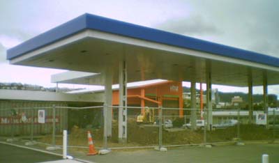
In Buckle St yesterday, I noticed that the service station near the corner with Tory St was undergoing what is either some very heavy refurbishment or complete demolition. The fact that the petrol tanks were being dug up makes me suspect the latter.
 While this may be nothing significant, I can't help wondering whether this might be the first steps towards creating a park here. The "Te Aro Corridor" Appendix (1MB PDF) of the Central Area Review says that "it is intended to establish a linear park space directly opposite the War Memorial." While the map of this proposed park is intentionally sketchy, by superimposing it on an aerial photo you can get some idea of the space it would use:
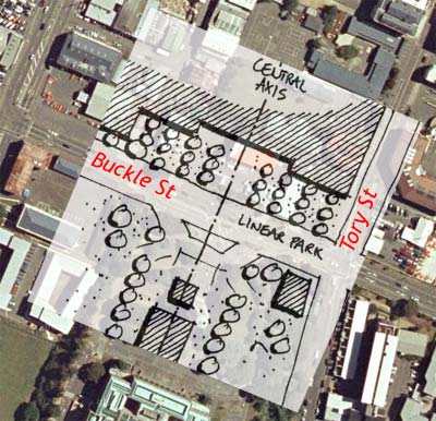
I don't think that this is will quite become the urban public space that I think upper Te Aro needs. It'll be dominated by the adjacent traffic, it's unlikely to develop an active built edge any time soon, and it's on the fringe of the urban area rather than forming the heart of an evolving neighbourhood. However, it's certainly a better use of the urban fabric than the current jumble of sheds and asphalt, and the main rationale for having a park here seems to be to maintain a clear view of and to provide a suitably formal backdrop for the War Memorial. It may even get a reasonable amount of use, since it's between Massey University and Mt Cook School, but it's too far from the emerging population centre of SoCo to provide the sort of quality public space required there.
Update: as I say in my latest comment, it looks like the use of this land for a National War Memorial Park is imminent.
posted by Tom @ 3:01 pm
![]()
![]()


13 Comments:
Seeing as it's just around the corner from the soup kitchen, how about we call it Glover Park II?
This is semi related but I'm going to post this anyway because I feel very strongly about this. Had the bypass been done properly the petrol station, hire pool and whatever else ugly is there would be gone. The road would be underground leaving tons of space for whatever. A much better park without arterial traffic cutting in between it and the war memorial perhaps. The bypass would be strong enough for buildings up to 4 levels to be constructed on top. This would provide a good barrier for high rise development between the city and the suburbs much like the motorway near the terrace does except without the huge visual impact. This means our mayor won't be able to build her high rises throughout te aro.
I seem to recall seeing some old drawings of this area showing the Museum and War Memorial, and a long park extending down the axis in between two new north-south streets from Buckle St to Vivian St. This was all concept I presume. But that would've been very cool.
While on the subject of parks, the other place I would've loved to seen a large formal park is extending from Parliament down to the waterfront, encompassing the block containing the grounds of the old parliament buildings, and the block which currently has NZ Post building on it (with the new apartments/hotel).
Info on the history of the war memorial:
http://www.nationalwarmemorial.govt.nz/hist.html
And, "Could smart urban design keep people fit and trim?"
http://www.sciencenews.org/articles/20070120/bob9.asp
Anon 1: "Had the bypass been done properly the petrol station, hire pool and whatever else ugly is there would be gone. The road would be underground leaving tons of space for whatever." It would certainly leave more space, but whether that would have been used for anything other than petrol stations, hire pool etc is a moot point.
"This would provide a good barrier for high rise development between the city and the suburbs much like the motorway near the terrace does except without the huge visual impact. This means our mayor won't be able to build her high rises throughout te aro." I'm not sure how that follows, since most of Te Aro is north of the motorway route. I think I'd still rather have a few highrises (though very little proposed for Te Aro is really all that high) than a motorway, underground or not.
Anon 2: I'm not sure whether it was planned as a park, more as a boulevard or avenue. As Dylan's link (thanks for that) says: "Its link to the city, the planned tree-lined boulevard from Buckle Street to Courtenay Place, had never been built". And from the same design guide appendix that I quoted earlier: "The original building
concept envisaged an avenue extending along the central axis and
cutting through Te Aro towards the north. This avenue has not been
built and never will be."
That would indeed have created an impressive sight, providing something sorely lacking in Wellington: a long viewshaft terminated by a building worth looking at. Think of the other missed opportunities we've had. Cuba St ends with an oblique view of a bit of the MFC; Willis St/Customhouse Quay ends with the Central Park flats or the NZ Post building; and it's best not to mention the north end of Canbridge Tce!
Having said that, I've always been a bit wary of these grandiose, Haussmannesque civic gestures. The vast boulevards and gleaming monuments of Paris, West London and Washington DC have always seemed great for parades but terrible for everyday living. And in this case, the destruction required to drive a wide road from Buckle St to Courtenay Pl would probably not have been worth it. It would also have left some very awkward left-over blocks between in and Tory St.
"I would've loved to seen a large formal park ... extending from Parliament down to the waterfront" Hmm, possibly. Certainly if the traffic on Featherston St & Waterloo Quay could be made to disappear, it could work. But I tend to think that with improvements to and better linkages between the public spaces along Bunny St, we could do just as well.
"Linear Park" Sounds a bit like code for "land set aside for a future enlarged road between the Terrace Tunnel and the Basin".
Aargh, I hope not! But I wouldn't put it past them.
Ix, that certainly makes sense. It's what I'd have done if I were the dictator of Wellington.
A four lane section connecting the Basin to Taranaki Street makes sense. (Of course it'd have been better if the trenched tunnel to Taranaki St had been built.)
But lets remember it doesn't have to be a surface road, reserving this space as a park allows easier construction of a tunnel down track too. And this will allow the park above this section to link up nicely with the memorial site. We just need to work better as a community next time to ensure this kind of outcome rather than the bypass style of outcome. (Because our leaders wont do it for us remember.)
"A four lane section connecting the Basin to Taranaki Street makes sense."
Why? Karo drive is (mostly) only two lanes, so why would extra capacity here help? Unless there are plans to switch the south-bound SH1 route from Vivian St & Cambridge Tce to Taranaki St and a widened Buckle St. I suppose that would fit in with the Basin Reserve flyover we hear mooted from time to time. Of course, that would only make sense if the Mt Vic tunnel were widened, and so on through Hataitai, and so one, and so on...
"We just need to work better as a community next time to ensure this kind of outcome rather than the bypass style of outcome."
You're assuming that the "community" all wants that kind of outcome. I'd have to agree with you that a tunnel covered with parks and/or buildings, displacing a bunch of temporary sheds, is better than the damage that the bypass caused. But that would cost even more money, and I (along with many others in the community) would prefer that it went towards a first-world public transport system rather than on yet more roads.
"Why? Karo drive is (mostly) only two lanes, so why would extra capacity here help?" [snip]
Yep, I agree. It would've made more sense if the bypass had been four lanes. But I still maintain that to close Courtenay Place, Vivien street should be reverted to two-way traffic. So that means as you suggest arterial traffic heading down Taranaki and across Buckle. While I see your point, where does it all end, the Basin Reserve would benefit from some improvements, e.g. a tunnel from Cambridge/Kent to Adelaide. A flyover to the tunnel means although traffic still would have to queue it would do it on the flyover rather than clogging Dufferin St and Kent Tce. I live right opposite the new ugly church they built here, I'm in favour of a flyover/tunnel combo because it'll improve access at a pedestrian level around the basin and allow the roadway around the basin to be narrowed (more trees anyone? remove the fence surrounding to the basin to open it up perhaps? etc.) Also remember flyover doesn't have to be ugly. Expose some steel, give it some flavour.
Oh and the tunnel would be necessary (well highly ideal) for light rail anyway. So its a useful investment in those terms.
It's actually not too bad on the (non-concrete) side which is mostly hidden from view, and inside it isn't so bad (checked it out when voting there the last election), but otherwise I don't really find it very inspiring. (each to their own :))
Actually what can be kind of creepy is walking up the Brougham/Paterson St side and catching the profile of a life size hanging corpse in the slot at the back.
Aargh, I should have done some more research before posting! There are definite plans to make the War Memorial Park happen. See the MCH website or Wikipedia article for details.
And it may very well be happening soon. The relevant quotes are:
"The land is currently tenanted and work on the park will begin once the leases expire and the land is vacated. It is expected that the park will be completed by 2008.
$6 million has been allocated for the acquisition of land to create a National Memorial Park, with $2.5 million in 2006/07 for the costs of landscaping to create the memorial park after the current leases have expired."
Post a Comment
<< Home