I can see my house from here - part 2
File under: maps, Wellington
Following on from my previous post, which concentrated on satellite imagery and aerial photography, this instalment will deal with online maps of Wellington. Google Maps has no street maps for New Zealand, just the medium-res satellite pictures I mentioned before, so we miss out on the nice interface and API mashup madness that it has inspired overseas. Thus, we'll look at the local offerings.
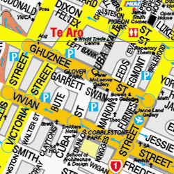 It's hard to go past Wises, an established name in New Zealand street maps. The map graphics are familiar from the print versions, and they show some interesting landmarks and amenities (including dealer galleries like Peter McLeavey!), though some of these are out of date: I wonder whether anyone's turned up to the "Repertory Theatre" on Dixon St and been surprised to run into a Drum & Bass gig at Stage? Also, to avoid potential embarassment, note that a cross above the word "Meth" refers not to a P dealer (that's further down Taranaki St) but to a Methodist church.
It's very much a street map, with bulbous oversized roads and an emphasis on parking buildings and the route to the airport, and it omits a lot of pedestrian connections. The interface seems a little clunky compared to Google Maps, but it's not too bad, and overall Wises is a good old reliable standby.
 An interesting alternative is Where Are We? Despite the cheesy name, this site (which concentrates on selling maps and software for GPS systems) provides a very good free online street finder and mapping system. You can follow a link to see a broad overview of Te Aro, but it's when you zoom right in that it gets really interesting.
This map is so detailed that it include property boundaries and street numbers! The legal boundaries don't always match up to what the casual observer would see on the ground: for example, Victoria St shows up as a patchwork of properties along what used to be Sturdee St before they were demolished to make the wide, winding arterial that we know and loathe today. But for someone who knows Wellington well, this just adds another fascinating layer and a deeper understanding of the urban environment. They get points off for gratuitous use of Comic Sans for street names, but their interface is easy to use, with proper Google-style panning.
 As well as the property boundary map, Where Are We? lets you choose LINZ's topographic maps from the NZTopoOnline server (though it's mostly to slow to use). These maps are also available direct from the LINZ site, which has its own map viewing interface with the catchy name ArcIMS Viewer (you have to go through the terms and conditions page first). These maps emphasise physical geographic features rather than streets, and indeed the streets disappear if you zoom in too far! So it's not so useful for urban purposes, but the contours and shading are nice at a regional scale.
Their viewer is much more complex and seriously cartographic than the others, with options to choose specific layers (just in case you want to see kilns and bivouacs but not moraine walls and fumaroles), convert between projections and download vector data in PDF or ESRI Shapefile format (though I haven't been able to test that). However, it can be a bit daunting for non-specialists, and it's often very, very slow.
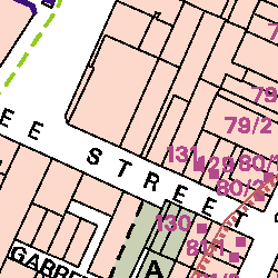 Back to detailed urban maps. The Wellington City Council has its District Plan maps online in PDF format, and these are also very useful. As well as showing various elements specific to the Plan, such as heritage buildings, significant trees and natural hazard zones, these maps are also interesting for their detailed property boundaries, as this enlargement from the Te Aro map shows. They're not labelled with street numbers, but the advantage is that the maps are in a vector format rather than bitmaps (not that I'd recommend that anyone try reverse engineering PDFs, of course). The map of central area height limits also makes for interesting reading.
Update: there's a new mapping site on the block (ZoomIn), and it's looking very promising. I've added a post about it here.
The next instalments will cover more photographic and remote-sensing views of Wellington, as well as some more unconventional approaches to mapping.
posted by Tom @ 5:48 pm
![]()
![]()


0 Comments:
Post a Comment
<< Home