My first mashup
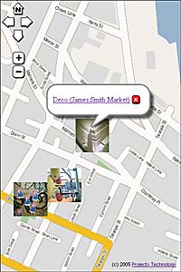 I've had a bit of a chance to play around with ZoomIn's more advanced features now, and while there's plenty you can do with the standard collaboration tools (adding places, photos and groups), the fun really starts when you start playing with the API. I've just created my first rudimentary mashup to show some of my Flickr photos on a map of central Wellington.
It probably doesn't quite fit the strictest definition of a mashup, since it's not reading the image URLs or geographic locations from feeds. Instead, I had to use the ZoomIn map-click example to manually find coordinates for the locations, then cut and paste the Flickr thumbnail URLs and descriptions from my Flickr RSS feed into the Javascript that drives the mashup. A proper mashup would have to read and parse the XML from that feed directly, then either look for addresses in the descriptions and use ZoomIn's geocoder to find the coordinates, or include a simple tool to let the user pinpoint the locations manually then save them to the server as XML. But since my server doesn't have scripting capabilities, and pure client-side scripting won't let you do HTTP requests on other servers, I've had to rely on a bit of kludging to try out the idea.
My brain's fizzing with other ideas for mashups, such as showing the following on a map:
- Wikipedia's Wellington suburb pages
- Observations from Weather Underground
- Resource constent applications from the city council website
- My Martini reviews
- Restaurant reviews from DineOut (there could be some nice visualisation possibilities there)
- Booth-by-booth results from last year's election (since I've already geocoded them by hand)
- Post from this blog, many of which are about specific locations
posted by Tom @ 11:22 am
![]()
![]()


2 Comments:
Martini first ! Location, and star rating out of 10 please Tom ! Can you put star rating on Zoomin?
My thoughts exactly! On the ZoomIn site itself, you can put whatever you like in the description of a place, but you can't (yet) choose your own icon for the place, so a map of star ratings wouldn't be possible.
With the API, though, it's possible to create whatever icon you want (I've used the thumbnails from my Flickr photos as my first example), so it's completely possible to create a nice geographic visualisation of Martini quality. First I need to geocode the bar locations, and I've done half the work since I've already got them mapped on my pocket PC, but I'm not looking forward to the projection conversion!
Post a Comment
<< Home