What's the plan?
The proposed Central Area district plan change that I alluded to the other day is a complex beast, and it may be a while before I get my head around it. I mentioned 35 pages, but that's just the report to last night's meeting (293kB PDF), not the full detailed plan change complete with policies, design guides and maps. While it's apparently a simplification of the current rules, it still adds up to over 500 pages, and is too big to be put online, so I'll have to wait for my requested hard copy to arrive before I can start analysing it properly.
In the meantime, there's enough information in the report to correct a few misconceptions in the media. I can understand that editorial time pressure combined with complexity and limited information can lead to inaccuracies, but I think that Wednesday's Dominion Post article (page A4, not online) headed "New rules may cut building heights in city" makes the proposed changes seem more restrictive than they will be.
The article says that "Building heights will be cut by up to 75 per cent", but the report (section 5.3.6.1) says that "the current high city/low city height limits are generally appropriate ... it is not proposed to significantly alter the height regime in the District Plan other than in identified heritage areas." So where does the 75% figure come from? The next section in the document refers to "setting the baseline for building mass at 75% of a theoretical 100% maximum".
That could indeed mean that the building is only 75% of the maximum height, but it's actually designed to give architects and developers the freedom to arrange that mass in creative ways. The building might cover only three quarters of the site, or have stepped setbacks (like an Art Deco skyscraper), or lightwells, or a modulated facade, or take on a modernist "podium and slab" typology. It could be pyramid-shaped, cone-shaped or gherkin-shaped. One would hope that in most cases, responsible developers would refrain from using the whole volume of a large site, to ensure good natural light for the tenants as well as neighbours, but this should encourage better urban design and more interesting buildings.
The article also says that "the city [will be] carved into nine new heritage sectors to protect distinctive areas from new developments". Yes, there will be nine heritage areas, replacing and adding to the existing heritage and "character" areas. However, rather than "carving" the whole central city into these areas, they only cover a small fraction of the central area: it's hard to tell without the official maps, but at a guess I'd say about 10%.
There's a table of all the areas on page 23, and it makes interesting reading. It certainly seems that some recent controversial schemes in Courtenay Place and Cuba Street would have been unlikely to have gone ahead if these rules had been in place earlier. For instance, Cuba Street between Dixon and Abel Smith streets currently has maximu heights of either 27 or 43.8 metres, but the proposed rules have a minimum of 12m and a maximum of 18m. Without the maps it's hard to tell how far from Cuba St a development would have to be set back to avoid the limits, but I don't think the ten-storey "Wellington" apartment and hotel development would have been possible. I like the idea of a minimum height as well as a maximum, since a 3-5 storey development would fit much better into the streetscape than a single-storey shed (or open air car yard, for that matter).
Here's a graph of the new and existing heights in the heritage areas. Note that some of the areas currently have a range of height limits: these ranges are shown by arrows.
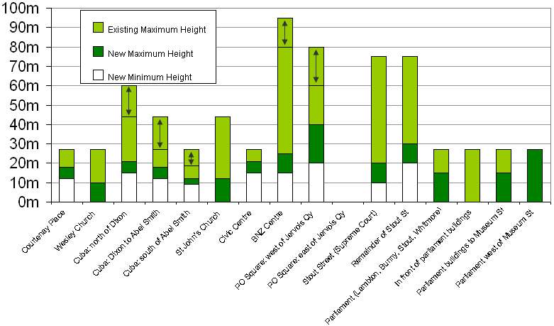
Another sentence in the article that confused me was "New buildings would be limited depending on their location, with the highest along the west side of Jervois Quay, tapering off away from the central business district." It seemed strange that Jervois Quay would have a higher limit than Lambton Quay or Willis St. But from the same table it looks like of the heritage areas, the western side of Jervois Quay adjacent to Post Office Square has the highest limit (40m). The rest of Jervois Quay retains a 60m limit, and the rest of the Lambton Quarter (with the exception of other heritage areas around Parliament, the Supreme Court and the old BNZ) will have the same height limits (75-95m above sea level) that they do now.
The article ends with a notable point: "Senior planning adviser Jeremy Blake said the height limits could be exceeded but any bigger building would have to be 'iconic' as it would stand out." According to the document (section 5.3.6.3), "waivers might be contemplated where a positive heritage or urban design outcome will be achieved. ... Such a policy is considered useful as landmark buildings of design excellence can visually enhance and add further interest to Wellington's cityscape." This is made more specific in the summary table on page 5, where it says "up to 35% additional height is provided for as a Discretionary Restricted Activity for all Central Area sites." Given that the maximum height limit (on west side of Willis St from Stewart Dawson Corner to opposite Bond St) is 95m, that theoretically allows for a skyscraper of 128m: several storeys taller than the 116m Majestic Centre.
Of course, I could be wrong, as I've only had a couple of evenings to read the summary of the plan, and the plan itself might contain other restrictions. In fact Cr Robert Armstrong, who should be familiar with the plans, said "a maximum building height of 40 metres (previously 95 metres) would strangle the city", according to the article. But my reading of the report suggests that these changes are far less restrictive than the article implies. Any comments from people who have been involved in the process (architects, planners, developers) would be most welcome.
Update: the plan changes have been approved for public feedback. The detailed plans and feedback form are on the council's Central Area Review page, and submissions close on the 27th of November.
posted by Tom @ 3:23 pm
![]()
![]()


1 Comments:
This sounds quite positive. Thanks for summarising something that I'd never find the time read.
The idea of restricting any new building to 75% of the site's volume is a fantastic way to at least require some thought to go into the design process (if I've understand the idea correctly).
Who are these people that buy these ugly, tacky, poorly constructed apartments that go up anyway? If it weren't for them developers might have to think about what they built.
I would still like to see the council take a more active approach to developing the inner city neighbourhoods, by coming up with coherent plans to create connecting lanes and squares through the very large inner city blocks Wellington unfortunately (or if managed properly, fortunately) has. If the council doesn't do this then it becomes a bit of a scatter shot random chance how things will turn out in 25 years, and you can bet the developers don't consider neighborhoods in their development approach.
The best example of this is what has happend to the block bounded by Taranaki St, Courtenay Plc, Tory St, and Vivien St. For a long period the interior of this block was an open car park. It presented a wonderful opportunity to develop community amenities, pedestrian lanes, square(s), and high density living in a coherent "attractive" manner. But with no proper planning this area is now covered by ugly apartment and car park complexes. All with faceless, private, foritified facades, and lifeless lanes (driveways) feeding their occupant carparking levels. No community amenities, and absolutely no positive neighborhood feeling.
Also, what ever happened to the old plan to widen many of the inner city streets? It seems many of them have been widened in parts but now new developments are going up and it is clear the council no longer has a policy to finish this. This means we will never be able to put trees _and_ bike lanes in many of the streets, it'll have to be one or the other, which is a shame and waste considering how much progress was made.
Post a Comment
<< Home